MAP
Survey Map
SP000901
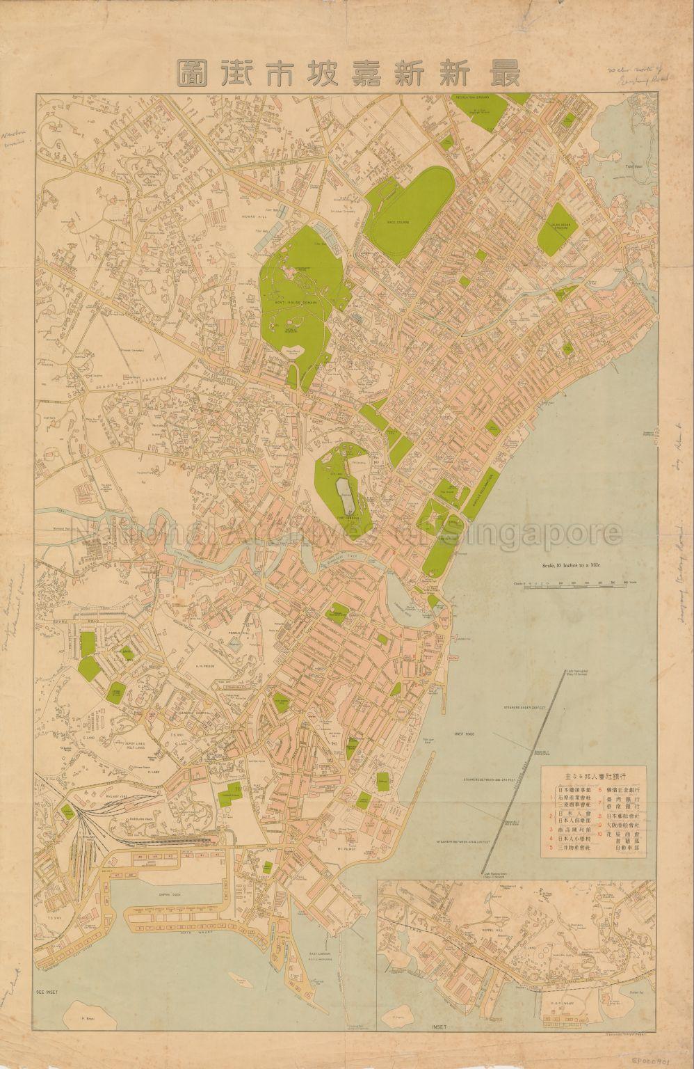
New Singapore Street Map
c.1932-1935
Map covers Balmoral Road, Stevens Road, Scotts Road, Orchard Road, Bras Basah Road, Prinsep Street, Bencoolen Street, Jalan Besar, Lavendar Street, Waterloo Street, Queen Street, Middle Road, Victoria Street, Hill Street, New Bridge Road, Kampong Bahru Road, North Bridge Road, South Bridge Road, Tanjong Pagar Road, Keppel Road, Cantonment Road, Stamford Road, Dunearn Road Kampong Road, Bukit Timah Road, Rochor Canal Road, Selegie Road, Serangoon Road, Race Course Road, Anson Road, Robinson Road, Telok Ayer Street, Cecil Street, Collyer Quay, Connaught drive, saint Andrew's Road, Johnston Pier and the surroundings. It shows Goodwood Hill, Monks Hill, The Manse Cavenagh Villa, Government House Domain, Race Course, Recreation Ground, Municipal Service Club, Jalan Besar Stadium, tidal basin, Rochor River, Eu Tong Sen Villa, Westey House, Cliff House, Ashton Lodge, burial grounds, Chinese cemetery, Fort Canning, Her Majesty Prison, Pearl's Hill, Tiong Bahru Singapore Improvement Trust Land, Sepoy Lines Golf Links, Singapore River, Chinese Recreation Club, Raffles Reclamation, Robinson and Company, John Littles, Meyer Chambers, Sailor's Institute, Empire Cinema, Empire Dock, Chinese temples, Hindu temples, mosques, godowns and others. It also consist an inset showing Telok Blanga (Blangah) Road, Kampong Bahru Road, Keppel Hill, Mount Faber, King's Dock, P & O Wharf, cattle wharf, telegraph wharf, oil wharf, Blangah Bay and others.
Map is likely drawn in the period of mid-1932 to 1935. Construction of Clifford Pier was planned in October 1929 and opened on 3rd June 1933. Johnston Pier thereafter was demolished by November 1935. The Tanjong Pagar railway station was completed in May 1932.
Map is likely drawn in the period of mid-1932 to 1935. Construction of Clifford Pier was planned in October 1929 and opened on 3rd June 1933. Johnston Pier thereafter was demolished by November 1935. The Tanjong Pagar railway station was completed in May 1932.
20120001565 - 0016
Nanyodo, Tokyo, Japan
Dates are estimated
Dates are estimated
Viewing permitted. Use and reproduction only with permission.
Credit line: Singapore Land Authority collection, courtesy of National Archives of Singapore
Processing of requests may require 3-5 working days
