MAP
Survey Map
SP000540
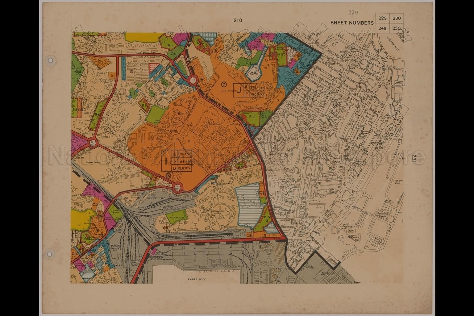
Town Map Sheet Number 230
1953
Singapore 230
Map covers land use in areas off Henderson Road, Tiong Bahru Road, Outram Road, Cantonment Road, Kampong Bahru Road, New Bridge Road, Neil Road, South Bridge Road, Keppel Road, Tanjong Pagar Road, Maxwell Road, Cross Street, Upper Pickering Street, Anson Road, Robinson Road, Telok Ayer Street, Cecil Street, Prince Edward Road, South Quay and surrounding areas. It shows planning district boundary, planning district number in residential density, central area boundary, cluster settlements, commercial buildings, Spottiswoode Park, Raeburn Park, flats at Tiong Bahru and Duxton Plain, Pearl's Hill Reservoir and waterworks, General Hospital, commercial zones, pockets of general industry areas, Federated Malay States flats and railway yard off Kampong Bahru Road, Motor car and Horses Loading Dock at Singapore Railway Station, Singapore Cold Storage Company Limited, Mansfield and Company Wharf Office and Export Duties Collection Office in Keppel Road, Empire Dock, Infant Welfare Clinic at junction of Neil Road and Tanjong Pagar Road, temples, Chinese temples, mosques, Maxwell Market, Telok Ayer Market, Children's Playground at Maxwell Road, Meyer Chambers at Raffles Place, Telok Ayer Basin, major traffic routes, and others.
Map covers land use in areas off Henderson Road, Tiong Bahru Road, Outram Road, Cantonment Road, Kampong Bahru Road, New Bridge Road, Neil Road, South Bridge Road, Keppel Road, Tanjong Pagar Road, Maxwell Road, Cross Street, Upper Pickering Street, Anson Road, Robinson Road, Telok Ayer Street, Cecil Street, Prince Edward Road, South Quay and surrounding areas. It shows planning district boundary, planning district number in residential density, central area boundary, cluster settlements, commercial buildings, Spottiswoode Park, Raeburn Park, flats at Tiong Bahru and Duxton Plain, Pearl's Hill Reservoir and waterworks, General Hospital, commercial zones, pockets of general industry areas, Federated Malay States flats and railway yard off Kampong Bahru Road, Motor car and Horses Loading Dock at Singapore Railway Station, Singapore Cold Storage Company Limited, Mansfield and Company Wharf Office and Export Duties Collection Office in Keppel Road, Empire Dock, Infant Welfare Clinic at junction of Neil Road and Tanjong Pagar Road, temples, Chinese temples, mosques, Maxwell Market, Telok Ayer Market, Children's Playground at Maxwell Road, Meyer Chambers at Raffles Place, Telok Ayer Basin, major traffic routes, and others.
20050001012 - AccNo339_30
Singapore 230 (30/33), Federation of Malaya No. 154-1953
English
This is part of a set of 33 maps (SP000511 to SP000543)
Survey Department, Federation of Malaya
Viewing permitted. Use and reproduction require written permission from copyright owner.
Seek permission from URA for reproduction
Processing of requests may require 3-5 working days
